The Megalithic Phenomenon and the Architecture of Anxiety

The Architecture of Anxiety: Prehistoric Paranoia in Southern Spain

By Nick Nutter | Published: 2026-10-11 | Updated: 2026-10-11

Visited 121 times

As megalithic construction moved east into the geographic bottlenecks and arid badlands of southern Spain, architecture shifted from open communal spaces to fortified territorial anchors. This chapter explores the "Architecture of Anxiety" in Copper Age Iberia, tracing how accelerating climate change during the Holocene Arid Climax drove societies to construct massive dolmens, hydraulic moats, and ultimately, militarised stone fortresses. From the terrestrial alignments of Antequera to the systems collapse at Los Millares, the architectural record reveals a cascading crisis of demographic pressure, territorial paranoia, and the death of the egalitarian Neolithic consensus.

The Architecture of Anxiety: Prehistoric Paranoia in Southern Spain - Peña de los Enamorados as seen from the dolmen Menga
Peña de los Enamorados as seen from the dolmen Menga

The Anxiety of Cabotage and Trade

As megalithic construction moved east from the coastal estuaries and the Guadalquivir basin, it encountered a geographic bottleneck. The Sub-Baetic depression at Antequera forms a natural inland crossroads. It connects the fertile plains of the Guadalquivir to the Mediterranean coast and the rugged mountainous interior. For communities navigating the escalating pressures of the Holocene Arid Climax, controlling this transit hub became a strategic necessity.

The Architecture of Anxiety: Prehistoric Paranoia in Southern Spain - Dolmen Romeral (Antequera)
Dolmen Romeral (Antequera)

The Inland Crossroads: Antequera

The architecture at Antequera maps a definitive escalation in territorial anxiety over a thousand years, captured in three separate monuments: Menga, Romeral and Viera.

Dolmen de Menga: The Terrestrial Anchor

During the Holocene Climatic Optimum, the Sub-Baetic depression was warm, moist, and forested with oak and pine. By 3800 BCE, this optimal climate was ending. An era of progressive aridification set in across the Iberian Peninsula [Carrión et al., 2010].

The landscape was degrading. Forests thinned, replaced by expanding Mediterranean scrubland and dry steppe. As the wider plains desiccated, the Guadalhorce river, which cuts through the Antequera depression, became a lifeline supporting a shrinking corridor of gallery forests. The local clans were not building Menga for no reason; they were engineering a territorial anchor at a time when arable land and reliable water were becoming contested resources.

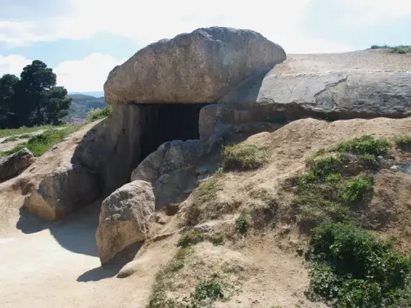
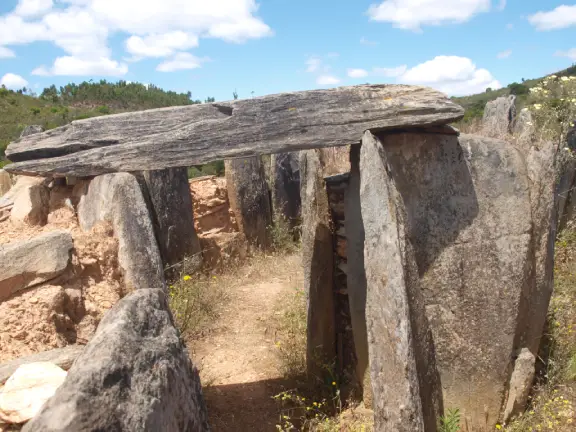
Built between 3800 and 3600 BCE, the Dolmen de Menga is a massive engineering achievement. It is a gallery grave stretching 27.5 metres, culminating in a capstone estimated to weigh 180 tons. The logistics required to construct Menga demanded an unprecedented centralisation of labour [García Sanjuán et al., 2014].

Apart from its size, Menga’s primary difference lies in its orientation. Standard Iberian megaliths align with the eastern horizon to capture the sunrise. Menga breaks this rule. It points northeast, aligning with the Peña de los Enamorados, a mountain with a distinct human profile [Hoskin, 2001].

This deviation is a deliberate territorial statement. The builders ignored celestial alignment to tie their lineage permanently to an unmistakeable geological landmark. In a landscape defined by shifting populations and the anxiety of exchange, Menga served as a terrestrial anchor. The local clan embedded their right to the crossroads into the mountain itself.

Tholos de El Romeral: The Elite Shift

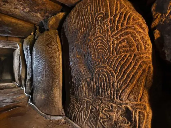
Constructed between 3000 and 2800 BCE, the Tholos de El Romeral sits four kilometres from Menga and Viera. Romeral abandons the orthostatic gallery design. It is a chambered cairn featuring a long corridor of drystone walls culminating in two consecutive false domes.

Like Menga, Romeral ignores the sunrise, aligning instead with the Camorro de las Siete Mesas in the El Torcal mountain range. However, Romeral reflects a fundamental shift in social structure. Like the tholoi at Valencina, it marks the arrival of a wealth-hoarding Copper Age elite.

The architecture shifts away from the open, communal defiance of Menga into restricted ritual spaces. The chambers of Romeral are tight and segmented, designed to restrict access. It represents a society where territorial anxiety had mutated. Anchoring the clan to the landscape was no longer sufficient; the new hierarchy required enclosed spaces to hoard prestige and conduct esoteric rituals away from the collective. The open territorial claims of the early farmers had ended. The era of the locked-down elite had begun.

Dolmen de Viera: The Celestial Control Group

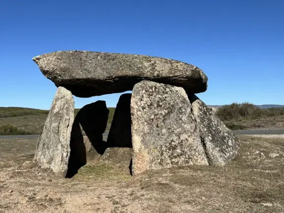
Almost as soon as Romeral was finished, around 2800 BCE, the Dolmen de Viera was constructed just 70 metres from Menga. Viera is a standard passage grave, extending 21 metres and terminating in a small, square burial chamber.

Unlike Menga and Romeral, Viera follows orthodox megalithic tradition. It faces east at an azimuth of 96 degrees, aligning with the morning sun during the spring and autumn equinoxes [Hoskin, 2001].

Viera proves that Menga’s terrestrial alignment was not a forgotten tradition. The Antequera communities still understood celestial alignments. Viera demonstrates a society hedging its bets. Even as local elites made idiosyncratic claims on the immediate geology, they maintained the ancient, celestial traditions of the wider Neolithic world.

The Empty Anchor and the Arriving Wealth

To understand this location's significance, we must look at the environment and geography of the mid-Holocene and the material evidence recovered from the transit routes.

Barely 200 metres from Menga sits Cerro de Marimacho, a Chalcolithic open-air agricultural village [García Sanjuán et al., 2014]. This was not a market town, and the dolmens were not meant to act as signposts or identifiers of such a place. The local clans were farmers.

They were farming in a valley that served as a geographic bottleneck. Anyone moving herds or goods between the coast and the interior had to pass through this depression. By building Menga, the farmers at Marimacho were claiming ownership of the land itself. They reasoned, correctly, that by holding the valley, they controlled the transit route.

Over the next millennium, the products travelling along the transit route changed. By 3000 BCE, the corridor flooded with the prestige economy of the Copper Age.

Because Menga and Viera were plundered in antiquity, they lack primary grave goods. The evidence for this influx of wealth is found in the later, restricted tombs of the Copper Age elite. Excavations at the Tholos de El Romeral, alongside the nearby Chalcolithic necropolises of Alcaide and Las Aguilillas, reveal a steady flow of materials that do not naturally exist in the Antequera depression [Aranda Jiménez et al., 2020].

The later elites hoarded marine shells harvested from the Mediterranean coast. They acquired tabular flint from the high sierras of Granada and amassed prestige items crafted from Sicilian amber and African ivory [Murillo-Barroso et al., 2018].

These goods did not arrive via merchant caravans. They moved through down-the-line exchange, passed hand-to-hand between clans to seal marriage alliances, resolve disputes, or secure grazing rights [Chapman, 2003]. The medium of exchange was social debt backed by geographic access. Coastal herdsmen gifted these rare items to the Antequera elites to secure safe passage through the chokepoint and access to inland pastures.

The original builders of Menga claimed a shrinking green corridor to ensure their survival. A thousand years later, the builders of Romeral used that exact chokepoint to intercept and hoard the wealth of a peninsula-spanning trade network.

The Ditched Enclosure of Marroquíes Bajos

Moving east from Antequera into the upper Guadalquivir basin, the landscape dictated a different defensive strategy. As agricultural populations swelled beyond the carrying capacity of the open plains, society physically enclosed itself.

Located in the modern city of Jaén, Marroquíes Bajos was a Copper Age macro-village covering 113 hectares. Occupied intensely between 2500 and 2000 BCE, the site is defined by five concentric ditches and earthworks [Zafra et al., 1999].

This site represents the anxiety of mass population and water management. Unlike contemporary communities in the rocky southeast who built defensive stone walls at Los Millares, the inhabitants of the clay-rich Guadalquivir basin dug immense moats. These ditches served a dual purpose. They captured and managed scarce water resources during the arid climax, and they provided a physical defence against competing groups [Díaz-Zorita Bonilla et al., 2018]. Marroquíes Bajos illustrates how the "Architecture of Anxiety" adapted to local geology, serving as the hydraulic equivalent of the militarised stone forts to the east.

The Generational Grind: The Necropolis of Panoría

Further east, approaching the badlands of the Granada Geopark, the Darro river valley hosts the Necropolis of Panoría.

Panoría consists of polygonal megalithic tombs that stand out not for their monumental scale, but for their longevity. Radiocarbon dating proves these specific tombs were used continuously for over a thousand years, from roughly 3500 to 2000 BCE [Aranda Jiménez et al., 2020].

Panoría illustrates the generational grind of territorial anxiety. Claiming and holding land was not a single declarative event. It required an active, multi-generational physical presence in the soil. As the climate worsened, local clans returned to the same tombs century after century. They continually added and removed bodies, using fresh burials to re-stamp their deed to the territory against rival groups.

The Architecture of Anxiety: Prehistoric Paranoia in Southern Spain - Petroglyphs at Gorafe
Petroglyphs at Gorafe

Gorafe and Oasis Siege Anxiety

Moving east from the Darro valley, the landscape deteriorates into the badlands of the Guadix-Baza basin in modern Granada province. Here, the Gor River cuts a deep gorge through an arid environment. It hosts the Gorafe complex, comprising over 240 dolmens. As the Holocene Arid Climax accelerated, local agro-pastoralists were forced to abandon the drying plains and concentrate in the Gor canyon, the only reliable water source in the region.

The psychological policing of this territory began at its borders. At the northern end of the Gor valley, the rocks overlooking the confluence of two valleys are carved with petroglyphs at sites like Cerro de las Minas, featuring bows, axes, and geometric motifs [Cámara Serrano et al., 2010]. Placed at a natural geographical junction, they acted as a warning to outsiders entering the bottleneck, the territory ahead was claimed, and the clans holding it were armed.

Just north of this junction lies the thermal springs of Alicún. Here, continuous mineral-rich warm water flows year-round, creating an oasis so heavily utilised that over millennia, mineral deposition and human management built a massive, raised travertine aqueduct known as the Acequia del Toril [García-García et al., 2020]. The local clans responded with rigid territoriality, constructing the Dolmenes de Alicún alongside the warm water channels to enforce their ownership of the spring.

Moving south into the main Gor canyon, archaeologists have identified roughly eleven separate settlements crammed into a 10-kilometre stretch of the valley bottom [Afonso Marrero, 1993]. Each settlement was strategically situated on a raised natural mound, featuring defensive wooden stockades surrounding clusters of round, wattle-and-daub huts.

The megaliths above them functioned as property deeds. Along the high, flat rim of the valley, the dolmens tend to be small stone cists. The larger, more elaborate passage graves were constructed on the terraced sides of the valley, formed by prehistoric landslips [Esquivel et al., 2012]. These larger dolmens were deliberately positioned on these stepped terraces to directly overlook the specific stockaded settlements below.

The material culture recovered from these tombs reveals a shared ideology of protection and status. Excavations across the necropolis have yielded characteristic slate and schist plaque idols, engraved, geometric representations of ancestral eyes and bodies that mirror those found across southern Iberia from the Alentejo to the southeast [Bueno Ramírez et al., 2019]. The ideological weight embedded in these stones is demonstrated by artifacts such as the rare, decorated anthropomorphic stela recovered from the valley and now preserved in the Centro de Interpretación del Megalitismo in Gorafe. This carved slab was deliberately reused as a structural element within one of the dolmens [Málaga Guerrero, 2004], physically rewriting the ancestral narrative, substituting older symbols of lineage with a permanent architectural claim to the contested soil. The megaliths served as physical markers, warning any rival group moving along the river that the water and the land below were permanently claimed.

The Architecture of Anxiety: Prehistoric Paranoia in Southern Spain - Badlands of Gorafe
Badlands of Gorafe

The Conservative Periphery: Panoria and Gorafe

The grave goods recovered from both the Necropolis of Panoria and the Gorafe canyons reveal communities that were connected to a regional terrestrial network, but completely excluded from the hyper-exotic, international maritime trade.

At both sites, archaeologists have recovered marine shells (such as Pecten and Dentalium) pierced to form necklaces and bracelets, alongside greenstone (variscite) beads. Because Panoria and Gorafe are located in the arid, high-altitude badlands of the Granada interior, these items prove the communities were not totally isolated. The seashells demonstrate a clear, formalised trade link to the Mediterranean coast, roughly 100 kilometres away. The variscite is even more telling; it was likely mined in the Pico Centeno deposits in Huelva, meaning these inland herders were plugged directly into the broader Iberian drovers' network.

However, the true significance of the grave goods at Panoria and Gorafe lies in what is explicitly missing.

Unlike the sprawling estuarine node of Valencina or the fortified settlement of Los Millares, these inland dolmens contain absolutely zero evidence of international prestige goods. There is no African ivory. There is no Sicilian amber. There are no ostrich eggshells, no rock crystal daggers, and no massive hoards of copper weaponry. The vast majority of the grave goods are overwhelmingly modest and local, flint flakes, simple handmade ceramics, bone tools, and locally sourced polished stone axes.

Within our "Architecture of Anxiety" framework, this material divide perfectly illustrates the social geography of the era. It proves that the hundreds of dolmens in the Gorafe canyon and the Darro river valley were not built by wealthy, highly stratified elites controlling vast trade empires. They were built by conservative, egalitarian pastoralists.

These inland clans were facing the same severe aridification as the coast, but their anxiety was localised. They used the shared Iberian visual shorthand, the megaliths, to anchor their lineages to shrinking pastures and vital water sources. They traded for a few seashells and greenstones to maintain tribal alliances and secure mates, but they either could not access, or deliberately rejected, the extreme wealth and authoritarian social hierarchy that was simultaneously transforming the coastal mega-sites. They were the conservative periphery, clinging to their egalitarian clan structures while the coastal core consumed itself in a race for prestige.

The Architecture of Anxiety: Prehistoric Paranoia in Southern Spain - Reconstruction of the Copper Age settlement at Los Millares
Reconstruction of the Copper Age settlement at Los Millares

Los Millares: Paranoia, Collapse, and the Precursor to Systems Failure

As the transit routes terminate at the arid southeastern coast of Almería, the "Architecture of Anxiety" reaches its climax. The Los Millares citadel (occupied c. 3200 – 2200 BCE) is the ultimate physical manifestation of paranoia and demographic pressure. Whilst this fortified settlement was contemporaneous with Zambujal in Portugal, its eventual collapse was driven by a radically different catastrophe.

Situated on the sharp point of a commanding ridge, the settlement overlooks the confluence of the Andarax river and a smaller southwestern tributary, the Rambla de Huechar. During the third millennium BCE, the Andarax was a wide, navigable river cutting through a drying landscape. The narrow terraces alongside the river were cultivated by the Millares clan. The river itself was a communications highway, linking Los Milares with the Mediterranean Sea and into North African exchange networks [Molina & Cámara, 2005].

As the wider Almerían hinterland desiccated, this fertile valley became a magnet for displaced populations. The architecture maps this climate-driven migration. Around 3200 BCE, the elites governed from a small, fortified inner citadel (Wall I) at the tip of the promontory. As the population swelled, society was forced to repeatedly expand its defensive footprint. Between roughly 2800 and 2500 BCE, they constructed two additional lines of concentric stone walls (Walls II and III). Finally, around 2500 BCE, the outermost perimeter (Wall IV) was erected, enclosing a six-hectare urban footprint [Molina et al., 2004].

The most revealing aspect of this demographic explosion is where it stopped. Outside Wall IV lay a sprawling, 13-hectare necropolis of over 80 tholos tombs, continuously utilised from 3200 until the site's collapse around 2200 BCE [Aranda Jiménez et al., 2020]. The expanding population pushed right up to the edge of the ancestral burial ground, but the society maintained a strict ideological boundary between the living and the dead. The elites built Wall IV to divide the walled fortress from the city of the ancestors. The dead remained outside the gates.

To defend this swollen population and their monopoly on down-the-line exchange, which included copper metallurgy, imported ceramics, ivory, and North African ostrich eggshells, the fortifications became increasingly formidable [Lull et al., 2014]. The walls were reinforced with bastions, defended barbican gates, and arrow slits. To prevent surprise attacks, they constructed a network of thirteen forward-operating forts on the surrounding hills, ensuring visual control over the valley approaches, particularly the route taken by the copper ore from its source in the Sierra Gador [Molina et al., 2004].

At Los Millares, the egalitarian Neolithic consensus ended. The architectural progression, from the open, communal stone circles of the early farmers to the fortified bastions of the southeast, indicates that society was now defined by hoarding wealth and defending it with organised violence [Chapman, 2003].

The Ideological Divide and the Collapse of Los Millares

The material culture recovered from Los Millares exposes a sharp ideological divide between the coastal fortress and the inland badlands. While the Gorafe canyon represented the easternmost limit of the pan-Iberian slate plaque idols, the elites at Los Millares rejected this inland trend entirely. Their foundational ancestral cult relied on a localised and maritime-influenced vocabulary. They deposited phalange idols carved from animal toe bones, unadorned stone betyls, and high-prestige figurines crafted from imported North African ivory into their tholos tombs. The inland clans clung to a shared Iberian visual shorthand, but Los Millares developed its own distinct ancestral markers.

As systemic stress increased in the settlement’s final centuries, the Los Millares elites adopted a new international networking tool: Maritime Bell Beaker ceramics. Found in the upper levels of the tombs and the later occupation phases of the citadel, these comb-stamped, white-inlaid vessels arrived via the site's extensive Mediterranean trade routes. The adoption of these beakers did not replace their local goods; it supplemented them. It reveals a coastal elite looking outward to the sea, using an international drinking package to forge alliances and secure supply chains just as the broader Copper Age world began to unravel.

Despite its militarisation and international networking, Los Millares could not withstand the ultimate systemic shock: the 4.2-kiloyear BP aridification event that turned the already arid southeast into a dust bowl. Around 2200 BCE, despite its once fertile river valley and defensive walls, the citadel was abandoned. The collapse of Los Millares is a micro-scale precursor to the Late Bronze Age systemic collapses seen a millennium later across the eastern Mediterranean [Cline, 2014]. It was driven by a cascading failure: prolonged aridification fractured the interior pastoralist networks, the wider down-the-line exchange of metals and exotica ceased, and the social strain of maintaining a paranoid, fortressed society finally broke the polity from within. High walls could not save a civilisation when the interconnected web of the ancient world unravelled, leaving the valleys empty as the brutal, state-level Argaric culture rose in the mountains to take its place.

Visiting Los Millares

The Los Millares site is open to the public. The original archaeological area is very hard to interpret but there are some excellent diagrams and maps to help. Perhaps the most instructive part is dedicated to a reconstruction of what Los Millares would have looked like in 2800 BCE. Most of the artefacts from Los Millares are displayed at the Archaeological Museum in Almeria city.

Breakdown of Trust: Cabezo del Plomo

Rather than a coordinated Iberian arms race directed by a centralised authority, what we are witnessing during the 3rd millennium BCE is a systemic breakdown of trust. The "Architecture of Anxiety" did not require a sprawling empire to spread, it simply needed the shared, localised threats of climate stress and the disruptive arrival of prestige wealth. To see exactly how this localised paranoia manifested on the ground, we need look no further than the coastal watchtower of Cabezo del Plomo, about 140 kilometres (by sea) north east of the estuary of the Rio Andarax and Los Millares.

Situated on a rugged plateau at the foothills of the Sierra de las Moreras in Mazarrón, Murcia, Cabezo del Plomo occupies a classic ecotone [Muñoz Amilibia, 1983]. But to understand the true strategic power of this site, we must view the landscape through a mid-Holocene lens.

Around 3000 BCE, the Mediterranean was experiencing a climatic highstand. Sea levels were roughly one to two metres higher than they are today. The modern coastal plain that currently separates the archaeological site from the water did not exist; it has been built up over the last five millennia by alluvial runoff and eroded topsoil. During the Copper Age, the sea pushed significantly further inland, forming a deep, sheltered bay that stretched in a sweeping arc from modern Bolnuevo to the promontory above Puerto de Mazarrón [Goy et al., 2003]. The waters of this bay lapped almost directly at the base of the hill. Cabezo del Plomo was not a watchtower observing the coast from a distance; it was a waterfront citadel.

This paleogeography fundamentally upgrades the site's role in the prestige economy. Prehistoric maritime networks relied on cabotage—coastal hopping in small vessels. Crews could perhaps paddle 40 to 50 kilometres a day before needing a calm, protected beach to pull their vessels ashore. The deep Bolnuevo-Mazarrón bay was a welcome sanctuary. By building their fortress directly above this natural harbour, the elites of Cabezo del Plomo were locking down the maritime highway itself. They possessed the physical high ground to either tax, trade with, or raid any coastal traffic moving between the eastern seaboard and the great Andalucian hubs like Los Millares, some three to four days' paddling to the south.

Occupied from roughly 3200 to 2500 BCE, the settlement illustrates the escalating timeline of our anxiety framework. The village covers approximately 3,200 square metres. While the steep natural topography protected the northern and eastern flanks of the hill, the vulnerable western and southern approaches were sealed off by a massive, dry-stone defensive wall [Chapman, 1990].

This wall was reinforced with attached, projecting stone bastions. As any military historian will tell you, a community does not build projecting bastions to corral sheep. Bastions are a deliberate architectural adaptation designed to provide overlapping fields of fire for defenders armed with projectiles. Inside these heavily defended walls, the population lived in tightly packed, circular huts with stone bases and reed roofs, huddled together behind their fortifications.

Excavations conducted by the University of Murcia between 1979 and 1985 revealed an economy caught in the transition from egalitarian farming to defended wealth. The domestic spaces yielded heavy stone grinding tools for processing grain, alongside abundant flint arrowheads and geometric blades used for hunting and defence [Muñoz Amilibia, 1983]. These grave goods demonstrate their connection to the regional exchange routes. The dead were buried with plain ceramics featuring perforated lugs, but they were also adorned with greenstone beads (likely variscite or calaita) and pierced marine shells.

Like the herders at Panoria and Gorafe, the people of Cabezo del Plomo were plugged into the regional prestige network. But unlike the inland herders, these inhabitants had a fixed, coastal surplus and control of a vital maritime chokepoint that they were willing to build a bastion to protect.

The true significance of Cabezo del Plomo within the context of Copper Age Iberia is how it combines the two distinct architectural reflexes of the era. Outside the defensive walls, at the foot of the hill near the ancient waterline, the community constructed a tholos (a false-dome megalithic tomb). Built around the mid-4th millennium BCE, it features a trapezoidal chamber formed by massive orthostats (upright standing stones) and is entirely enclosed within a circular earthen burial mound. Archaeologists have noted that the architecture of the tomb deliberately mimics the circular huts of the living settlement above it, serving as a permanent "second home" for the ancestors [Chapman, 1990].

Cabezo del Plomo encapsulates the dual nature of Copper Age anxiety. The community did not retreat into the high badlands like the Darro valley pastoralists, nor did they achieve the sprawling, terrifying wealth of the Ivory Lady at Valencina. Instead, they built a localised, stronghold. They used the tholos tomb at the base of the hill as a psychological anchor, establishing their ancestral right to the bay. Simultaneously, they built a bastioned fortress at the top of the hill to physically defend the grain, the greenstone, and the maritime routes from their neighbours.

Given the perceived importance of Cabo del Plomo, it is interesting to consider why there is no evidence of the trade in exotica, especially from North Africa, that we see at Los Millares. An explanation may be found by applying the principles of the distance decay model, the principle that the concentration of traded goods drops off the further you move from their source or primary point of entry into a region.

African prestige goods, like ivory and ostrich eggshells, did not cross the open Mediterranean. Instead, they likely entered Iberia through the narrowest chokepoint, the 14-kilometre Strait of Gibraltar. From there, the maritime trade bifurcated. One route moved northwest to Valencina, while the other pushed east to Los Millares. These massive apex hubs acted as economic black holes. They used their vast agricultural surplus and raw copper to absorb the incoming wealth. This created a strict distance-decay effect. By the time coastal traders paddled another 150 kilometres past Cabo de Gata to Cabezo del Plomo, the exotic supply was completely exhausted. The elites built their bastions not to guard international treasures, but to fiercely control the regional wealth that remained.

The Fatal Flaw of the Middleman: The Abandonment of Cabezo del Plomo

To fully dot the I's and cross the T's on the Iberian coastal narrative, we must look at how Cabezo del Plomo met its end. Its abandonment provides a third model of Copper Age collapse, distinct from both the environmental suffocation of Zambujal and the catastrophic climate shock that broke Los Millares.

Cabezo del Plomo was abandoned significantly earlier than its larger contemporaries, roughly around 2500 BCE. It did not survive to see the 4.2-kiloyear BP aridification event, nor was it conquered by the ensuing Argaric culture. Instead, its demise highlights the inherent fragility of the "Architecture of Anxiety": paranoia is incredibly expensive.

Maintaining a bastioned stone fortress on a steep, rocky plateau requires a continuous influx of surplus wealth. The inhabitants had to be fed, the walls had to be repaired, and the ritual elites had to be subsidised. For centuries, Cabezo del Plomo managed this by acting as a heavily armed gatekeeper, taxing and trading with the coastal cabotage moving through its protected bay. However, acting as a middleman is a dangerous economic game when apex hubs are consolidating power.

As the 3rd millennium BCE progressed, the colossal mega-sites, particularly Los Millares to the south and Valencina to the west, began to monopolise the maritime exchange networks. As these massive demographic black holes exerted greater gravitational pull on the coastal trade, the smaller, regional waystations were bypassed or economically squeezed out. Without the constant wealth generated from the prestige trade moving through their bay, the elites at Cabezo del Plomo lost their economic lifeblood.

The local agricultural yield alone was not enough to sustain a fortressed society. The abandonment of Cabezo del Plomo was not a violent apocalypse; it was an economic deflation. The "Architecture of Anxiety" became unsustainable, and the community quietly dispersed, leaving their bastions and their ancestors behind on the hill.

Mainland Summary

Before we leave the European mainland and move on to the Mediterranean islands, it is instructive to reflect on how our "Architecture of Anxiety" framework has evolved. Climatic stress and decreasing areas of agricultural land drove the Neolithic people in Brittany, northern Spain, Portugal, southwestern Iberia, and southern Spain to erect psychological barriers, stelae, stone circles, and dolmens to identify and protect their land, trading routes, and marketplaces. The form and style those barriers took differed depending on geography, geology, population, availability of resources, and perceived threats.

Towards the end of the megalithic period, psychological barriers proved insufficient against real threats to increasing wealth and riches. The tribes in the Gorafe area constructed wooden stockades, whilst those in the Guadalquivir valley, blessed with a deep topsoil and subsoil, dug massive ditched enclosures. At Zambujal (Portugal), Los Millares, and Cabezo del Plomo, where the bedrock is rarely below one metre beneath the surface, ditches were not practical. Those tribes built towards the sky, and we see the first deliberate, stone fortifications.

References and Further Reading

  • Afonso Marrero, J. A. (1993). Poblamiento y Transformaciones Sociales en el Neolítico y Edad del Cobre en la cuenca del río Gor.
  • Aranda Jiménez, G., et al. (2020). The chronological and social framework of the Panoría megalithic necropolis. Radiocarbon.
  • Aranda Jiménez, G., et al. (2020). Megalithic funerary practices in the Iberian Peninsula.
  • Bueno Ramírez, P., et al. (2019). Plaque idols and graphic expression in Iberian megalithism.
  • Cámara Serrano, J. A., et al. (2010). Rock art and territoriality in the Gor River Valley.
  • Carrión, J. S., et al. (2010). Expected trends and surprises in the Lateglacial and Holocene vegetation history of the Iberian Peninsula and Balearic Islands. Review of Palaeobotany and Palynology.
  • Chapman, R. (1990). Emerging Complexity: The Later Prehistory of South-East Spain, Iberia and the West Mediterranean. Cambridge University Press.
  • Chapman, R. (2003). Archaeologies of Complexity. Routledge.
  • Cline, E. H. (2014). 1177 B.C.: The Year Civilization Collapsed. Princeton University Press.
  • Díaz-Zorita Bonilla, M., et al. (2018). The Copper Age settlement of Marroquíes Bajos (Jaén, Spain). Journal of Anthropological Archaeology.
  • Esquivel, J. A., et al. (2012). Geographical Information Systems applied to the spatial analysis of the Gorafe megalithic necropolis. Journal of Archaeological Science.
  • García Sanjuán, L., et al. (2014). The Menga Dolmen (Antequera, Spain). Antiquity.
  • García-García, F., et al. (2020). Travertine systems and human occupation in the Alicún de las Torres hydrothermal area.
  • Goy, J. L., Zazo, C., & Dabrio, C. J. (2003). A Quaternary sea-level curve for the Spanish Mediterranean coast. Palaeogeography, Palaeoclimatology, Palaeoecology. (Provides the geological context for the mid-Holocene highstand and the formation of inland embayments along the southeastern coast).
  • Hoskin, M. (2001). Tombs, Temples and their Orientations: A New Perspective on Mediterranean Prehistory. Ocarina Books.
  • Lull, V., et al. (2014). The Bronze Age in the Iberian Peninsula.
  • Málaga Guerrero, J. (2004). Las estelas decoradas en el megalitismo andaluz.
  • Molina, F., et al. (2004). Los Millares y la periodización de la Prehistoria Reciente del Sureste. Simposio de Prehistoria Cueva de Nerja.
  • Molina, F., & Cámara, J. A. (2005). Guía del Yacimiento Arqueológico Los Millares.
  • Muñoz Amilibia, A. M. (1983). El poblado eneolítico del Cabezo del Plomo (Mazarrón, Murcia). Anales de la Universidad de Murcia.
  • Murillo-Barroso, M., et al. (2018). Amber in prehistoric Iberia: New data and a review. PLOS One.
  • Zafra, N., et al. (1999). Una macro-aldea en el origen del modo de vida campesino: Marroquíes Bajos (Jaén). Trabajos de Prehistoria.
Legacy Reloaded: A dev, an AI, and the relentless pursuit of 100

Enjoying this clean, uncluttered read?

You are currently browsing the result of a massive technical overhaul. My new book, Legacy Reloaded: A dev, an AI, and the relentless pursuit of 100, chronicles the journey of transforming an aging legacy website into a modern, lightning-fast platform that hits the perfect 90+, 100, 100, 100, 3/3 Lighthouse metrics. It’s a story of collaboration between developer and AI, and the stubborn pursuit of technical perfection.

Read the Story

You have finished reading chapter 6

More articles in the The Megalithic Phenomenon and the Architecture of Anxiety series: